Mountain Halls: Difference between revisions
From Drunkapedia
imported>Tlosk m (Text replace - " Map available at ACMaps.com]" to "}}") |
imported>Arkalor No edit summary |
||
| Line 13: | Line 13: | ||
| | | | ||
| Coordinates = 10.1N 56.7W | | Coordinates = 10.1N 56.7W | ||
| Landblock = | | Landblock = 0192 | ||
| Dereth Map = {{Map Point|10.1|N|56.7|W|Marker=Dungeon}} | | Dereth Map = {{Map Point|10.1|N|56.7|W|Marker=Dungeon}} | ||
| Nearest Town = [[Fort Tethana]] | | Nearest Town = [[Fort Tethana]] | ||
Revision as of 14:06, 30 January 2012
| Maps NPCs Creatures Items and Objects Portals Images Update History |
| Mountain Halls | |
|---|---|
| Quests | N/A |
| Restrictions | Level: 15+ Tieable: No Recallable: No Summonable: No |
| Coordinates | 10.1N 56.7W near [[Fort Tethana]] |
| Nearest LS | ?? |
| Route | Run from Fort Tethana |
| Map Files: | ACMaps Map |
Show location on Dereth map
| |
| 0192 | |


[[Category:Dungeons: Fort Tethana]]
General
This used to be one of the less camped leveling places for young archers, partly because of the convenient Lifestone near the Empyrean Stone Tower just outside and the bottom levels also providing Drudge Raveners for their guts.
Now it is mostly used to finish the Kilif Zefir Kill Task
Maps
- Map (from ACMaps.com)
- Wiki Map:
NPCs
- None
Creatures
Items and Objects
 Chest - Unlocked, see map
 Font - casts Revitalize Other I
- Random Loot spawns on the ground in the bottom drudge Room
Portals
- Surface - near drop and at the end, see map
Images
Click image for full size version.
-
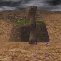
Entrance to Mountain Halls
-
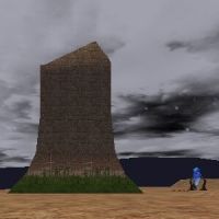
Lifestone and Empyrean Tower just outside the dungeon
-
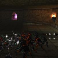
Bottom Room with drudges, random loot, chests and exit portal


