Middle Osteth: Difference between revisions
imported>Arkalor |
imported>Arkalor |
||
| Line 650: | Line 650: | ||
=== [[Lifestone]]s === | === [[Lifestone]]s === | ||
''For Middle Osteth town lifestones, see each town's dedicated page'' | ''For Middle Osteth town lifestones, see each town's dedicated page'' | ||
{|class="wikitable" | |||
!Coordinates | |||
!Location/Point of Interest | |||
|- | |||
|27.4N, 63.7E | |||
|North of [[Merchant Cellar]] | |||
|- | |||
|25.0N, 56.7E | |||
|Northeast from [[Isle of Tears]] | |||
|- | |||
|25.1N, 37.7E | |||
|[[Fort Witshire]] | |||
|- | |||
|23.4N, 7.7W | |||
|[[Wilderness Fort]] | |||
|- | |||
|21.0N, 18.6E | |||
|Mount Zabool | |||
|- | |||
|19.7N, 3.3W | |||
|[[Gharu'ndim Outpost]] | |||
|- | |||
|12.2N, 2.4E | |||
|[[Four Towers]] | |||
|- | |||
|9.0N, 43.4E | |||
|West of Rithwic | |||
|- | |||
|4.4N, 35.5E | |||
|[[Adventurer's Haven]] | |||
|- | |||
|3.9N, 70.5E | |||
|[[3.9N, 70.5E - Village|Village]] | |||
|- | |||
|1.9N, 41.6E | |||
|[[1.9N, 41.6E - Larry the Rabbit Master's Farm|Larry the Rabbit Master's Farm]] | |||
|- | |||
|4.5S, 23.5E | |||
|[[4.5S, 23.5E - Merchant Tent|Merchant Tent]] | |||
|- | |||
|5.0S, 58.3E | |||
|[[5.0S, 58.3E - Lifestone Building|Building]] | |||
|- | |||
|8.7S, 53.8E | |||
|[[Folthid Estate]] | |||
|- | |||
|8.8S, 75.2E | |||
|Southeast of Dryreach | |||
|- | |||
|17.6S, 70.7E | |||
|Southwest of Dryreach | |||
|- | |||
|19.8S, 47.9E | |||
|[[Blackmire Swamp]] | |||
|- | |||
|20.6S, 44.2E | |||
|[[20.6S, 44.2E - Roadside Vendors|Roadside Vendors]] | |||
|- | |||
|25.6S, 57.6E | |||
|[[25.6S, 57.6E - Archmage Hut|Archmage Hut]] | |||
|- | |||
|25.7S, 74.7E | |||
|[[25.7S, 74.7E - Peddler's House|Peddler's House]] | |||
|- | |||
|28.6S, 78.1E | |||
|[[28.6S, 78.1E - Advocate Ruins|Advocate Ruins]] | |||
|- | |||
|30.3S, 94.7E | |||
|South of Tou-Tou | |||
|- | |||
|31.3S, 3.6E | |||
|Inner Sea shoreline | |||
|- | |||
|31.5S, 37.1E | |||
|[[31.5S, 37.1E - Archmage Tower|Archmage Tower]] | |||
|- | |||
|33.7S, 79.9E | |||
|[[33.7S, 79.9E - Archmage's Tower|Archmage's Tower]] | |||
|- | |||
|34.8S, 60.5E | |||
|[[35.1S, 60.5E - Peddler and Lifestone|Peddler and Lifestone]] | |||
|- | |||
|34.4S, 64.9E | |||
|[[Fycheck Outpost]] | |||
|- | |||
|36.1S, 44.3E | |||
|Southwest of Blackmire Swamp | |||
|- | |||
|47.2S, 10.6E | |||
|Inner Sea shoreline | |||
|- | |||
|51.3S, 40.3E | |||
|[[51.3S, 40.3E - Abandoned Sho Building|Abandoned Sho Building]] | |||
|- | |||
|} | |||
=== [[Portal]]s === | === [[Portal]]s === | ||
Revision as of 11:12, 24 February 2012
Related topics: Osteth
| Introduced: | Release |
 |
Description
"All three human heritages possess footholds in this immense, fertile plain. At the mouth of the River Prosper, the new Sho community Hebian-to has erected the Laughing Kirin Hall and the Shining Shield Tavern to give would-be vassals a place to seek out suitable patrons. To the north, the Isle of Tears rises in the midst of Lake Blessed. This island is the legendary site of the Underground City, where the hero Thorsten Cragstone dwelt during the Olthoi war, and where some say his tomb now rests amid lairs of vicious Mosswarts."[1]
Related Quests
Kill Tasks
NPCs
| NPC Name | Location | Type | Details |
| Fadsahil al-Tashbi the Master Archmage | 40.3S, 11.2E | Shopkeeper | Magical Supplies |
Aluvian Realm
Towns
Regions
Sho Nation
Towns
Regions
Gharu'ndim Kingdom
Towns
Regions
- A'mun Desert
- Inner Sea Gear Knight Invasion Area - Level 30-60 area
- City of Neftet - Level 180+ area
- Falamar Hills
- Mount Alphus Range
- Yaraq Cove
- Yushad Ridge
Items
 Berimphur Plant
 Colban Plant - Found in the Blackmire Swamp
 Lapyan Plant
 Minalim Plant
 Verdalim Plant
 Dirty Old Crate
 Sunflower
 Directive's Cache - Found in the A'mun Desert
 Master's Holding - Found in the south of the A'mun Desert
Points of Interest
Middle Osteth (North)
Middle Osteth (South)
Lifestones
For Middle Osteth town lifestones, see each town's dedicated page
| Coordinates | Location/Point of Interest |
|---|---|
| 27.4N, 63.7E | North of Merchant Cellar |
| 25.0N, 56.7E | Northeast from Isle of Tears |
| 25.1N, 37.7E | Fort Witshire |
| 23.4N, 7.7W | Wilderness Fort |
| 21.0N, 18.6E | Mount Zabool |
| 19.7N, 3.3W | Gharu'ndim Outpost |
| 12.2N, 2.4E | Four Towers |
| 9.0N, 43.4E | West of Rithwic |
| 4.4N, 35.5E | Adventurer's Haven |
| 3.9N, 70.5E | Village |
| 1.9N, 41.6E | Larry the Rabbit Master's Farm |
| 4.5S, 23.5E | Merchant Tent |
| 5.0S, 58.3E | Building |
| 8.7S, 53.8E | Folthid Estate |
| 8.8S, 75.2E | Southeast of Dryreach |
| 17.6S, 70.7E | Southwest of Dryreach |
| 19.8S, 47.9E | Blackmire Swamp |
| 20.6S, 44.2E | Roadside Vendors |
| 25.6S, 57.6E | Archmage Hut |
| 25.7S, 74.7E | Peddler's House |
| 28.6S, 78.1E | Advocate Ruins |
| 30.3S, 94.7E | South of Tou-Tou |
| 31.3S, 3.6E | Inner Sea shoreline |
| 31.5S, 37.1E | Archmage Tower |
| 33.7S, 79.9E | Archmage's Tower |
| 34.8S, 60.5E | Peddler and Lifestone |
| 34.4S, 64.9E | Fycheck Outpost |
| 36.1S, 44.3E | Southwest of Blackmire Swamp |
| 47.2S, 10.6E | Inner Sea shoreline |
| 51.3S, 40.3E | Abandoned Sho Building |
Portals
- 11.1N, 14.7E - Direlands Midland Portal
- 8.1S, 74.5E - East Direlands Swamp
- 26.3N, 63.9E - High Mountain Valley Portal
- 19.7N, 3.3W - North Desert Edge
- 18.7S, 6.8E - Southern Mt. Esper Portal
Dungeons
Creatures
Note: Most landscape creatures have a spawn map on the creature's article page. [[File:<<Class 1>> Icon.png|link=<<Class 1>>]] [[<<Class 1>>]]
- [[<<Creature 1>>]]
- [[<<Creature 2>>]]
Images
-
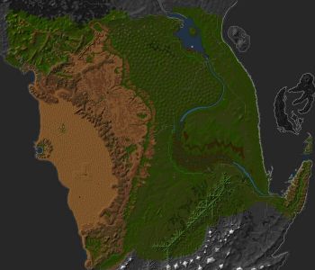
Middle Osteth
-
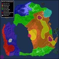
Spawn Distribution Map

