South Direlands: Difference between revisions
From Drunkapedia
imported>Arkalor (→Items) |
imported>Arkalor |
||
| Line 239: | Line 239: | ||
=== [[Lifestone]]s === | === [[Lifestone]]s === | ||
* [[ | * [[Obsidian Rim|48.0S, 65.1W]] | ||
* 51.7S, 71.0W - Black Hills | * 51.7S, 71.0W - Black Hills | ||
* [[73.4S, 36.1W - Peddler and Lifestone|73.4S, 36.1W]] | * [[73.4S, 36.1W - Peddler and Lifestone|73.4S, 36.1W]] | ||
Revision as of 17:59, 21 March 2012
 |
Description
The large area of the Direlands bordered by the Valley of Death and the East Direlands Swamp to the north/north east. The Southern Landbridge connects this part of the Direlands to Southern Osteth.
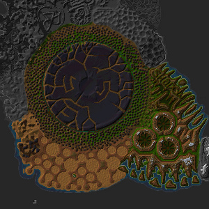
The most prominent feature of the southern Direlands is the dark round landmass known as the Obsidian Plains.
Route
- Black Hill: Use the Black Hill Portal in the Desert March dungeon.
- Direlands Midlands: Use the Direlands Midland Portal in the Sylsfear Dungeon.
- South Direlands Craters: Use the South Direlands Portal in the Wedding Hall.
Related Quests
- Asheron's Departure Lower
- Caul Flagging
- Crafting Golems
- Dire Champions
- Fiun Healing Machine Quest
- House Plants
- Major Sparking Stone Quest
- Metos Motes
- New Singular Repositories
- Pheraion's Sanctum Quest
- Preparation for the Ritus
- Rossu Morta Chapterhouse Access
- Shendolain Vestibule Quest
- Singularity Recall
- Sword of Lost Hope Quest
- Sword of Lost Light Quest
- The Temple of Hizk Ri
- Virindi Servant's Amulet Quest
NPCs
| NPC Name | Location | Type | Details |
| Garaena the Emissary | 87.7S, 65.6W | Miscellaneous | Casts portal to Aerlinthe for a D-note |
| Archmage (South Direlands Midland) | 88.1S, 60.9W | Shopkeeper | Magic Supplies |
| Merchant (South Direlands Midland) | 88.1S, 60.9W | Shopkeeper | General Supplies |
| Merchant (82.4S, 34.3W) | 82.4S, 34.3W | Shopkeeper | General Supplies |
| Peddler (South Direlands) | 73.4S, 36.1W | Shopkeeper | Basic Supplies |
| Armorer (South Direlands) | 82.6S, 70.1W | Shopkeeper | Armor |
| Roaming Bowyer (South Direlands) | 82.6S, 70.1W | Shopkeeper | Ammunition |
Items
Landscape Spawns
![]() Argenory Plant
Argenory Plant![]() Colban Plant
Colban Plant![]() Lapyan Plant
Lapyan Plant![]() Minalim Plant
Minalim Plant![]() Dirty Old Crate
Dirty Old Crate![]() Directive's Cache
Directive's Cache![]() Singularity Trove
Singularity Trove
Towns & Regions of the Southern Direlands
Obsidian Plains
Southeast Direlands
Towns
Regions
Southwest Direlands
Towns
Regions
Points of Interest
Emboldened POI are those indicated on the Ingame Map as yellow dots. See also Points of Interest Map
Lifestones
- 48.0S, 65.1W
- 51.7S, 71.0W - Black Hills
- 73.4S, 36.1W
- 74.1S, 52.4W
- 78.9S, 73.4W
- 80.8S, 70.0W
- 82.2S, 36.5W
- 84.2S, 48.8W
- 82.4S, 34.3W
- 88.1S, 60.9W
- 88.3S, 64.5W
- 88.9S, 67.3W
Portals
| Location | Coords | Destination | Coords | Restrictions |
| Black Hills | 74.1S, 52.4W | Direlands Northwest Shore | 5.8N, 91.0W | 25+ |
| Black Hills | 74.1S, 52.4W | Valley of Death | 42.9S, 63.5W | 25+ |
| Outside Candeth Keep | 88.5S, 66.8W | South Direlands/Landbridge Border | 84.2S, 34.4W | 12+ |
| South Direlands Craters | 78.1S, 48.6W | Desert Ridge Border | 5.6S, 40.0E | None |
| South Direlands Craters | 78.1S, 48.7W | South Direlands/Landbridge Border | 84.2S, 34.4W | 12+ |
| South Direlands Craters | 80.2S, 42.3W | Northern Landbridge | 24.4N, 53.8W | 12+ |
| Undead Ruins | 82.7S, 48.8W | Isle of Tears | 22.5N, 51.9E | None |
| Direlands Midlands | 90.2S, 64.5W | Direlands Desert Edge | 78.7S, 73.4W | 23+ |
Dungeons
Creatures
See:
Note: Most landscape creatures have a spawn map on the creature's article page. [[File:<<Class 1>> Icon.png|link=<<Class 1>>]] [[<<Class 1>>]]
- [[<<Creature 1>>]]
- [[<<Creature 2>>]]
Images
-
South Direlands
-
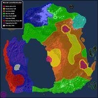
Spawn Distribution MAp

